84
Parroquias
2,397
Localidades
222,233
Registros censales
42,040
Hogares
2
Años del censo
- Personas
- 115,058
- Hogares
- 21,345
- Personas
- 107,175 -6.9%
- Hogares
- 20,695 -3%
Acerca de
County Clare is located on the west coast of Ireland in the province of Munster, bordered by Galway to the north, Limerick to the east and south, and the Atlantic Ocean to the west. The county encompasses approximately 3,188 square kilometers and is characterized by diverse landscapes ranging from the dramatic Cliffs of Moher in the north to fertile agricultural plains and boglands in the interior. The River Shannon forms much of the county's eastern boundary, and Clare's coastal position has shaped its climate, economy, and cultural identity throughout history.
The region has a long and complex history, with evidence of human settlement dating back thousands of years. Clare was part of the Kingdom of Thomond during the medieval period and was heavily influenced by the Norman invasion of Ireland. The O'Brien clan held significant power in the area for centuries, and their legacy remains evident in local place names and historical sites. During the Great Famine of the 1840s, Clare suffered severe population loss through death and emigration, a trauma that left lasting marks on the community and diaspora connections that persist today.
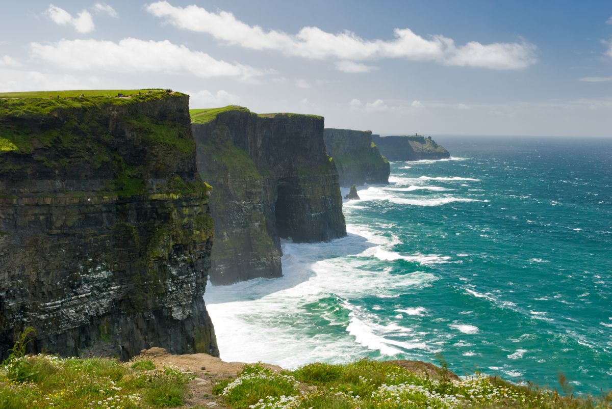
The Cliffs of Moher stand as Clare's most internationally recognizable feature, attracting hundreds of thousands of visitors annually with their breathtaking 214-meter-high sea cliffs stretching for about eight kilometers. Beyond this landmark, Clare is noted for its traditional Irish music heritage, particularly in areas like Doolin, which has become a center for traditional folk music and attracts musicians and tourists from around the world. The county also encompasses the Burren, a distinctive limestone landscape known for its unique flora and archaeological significance, including numerous prehistoric monuments and early Christian sites.
For the people of County Clare, the landscape and cultural heritage form the backbone of community identity and economic opportunity. Agriculture remains important, particularly dairy farming and sheep grazing, while tourism has become increasingly significant to the local economy. The county maintains strong connections to Irish language and culture, and traditional customs continue to play an important role in community life. Clare's position between rural tradition and growing international tourism represents both an opportunity and a challenge for sustaining local culture while adapting to contemporary economic needs.
Source: AI generated

Photo by Sarah Elizabeth on Unsplash
-
Jurisdicción
República de Irlanda
-
Nombre en irlandés
An Clár
-
Años del censo
1901, 1911
-
Distritos
191 distritos censales
- Logainm
Annals of the Four Masters
Historical references from O'Donovan's edition (1848–51)
32 places in this county are recorded in the Annals of the Four Masters.
*Kinelea*
The Annals of the Four Masters record Kinlea (Irish: Cinel-Aedha-na-hEchtghe) in 19 entries between AD 531 and AD 1609.
Inishcathy
The Annals of the Four Masters record Scattery Island (Irish: Inis-Cathaigh) in 9 entries between AD 861 and AD 1591.
*Lough Mask*
The Annals of the Four Masters record Lough Rask (Irish: Loch-Measga) in 7 entries between AD 1105 and AD 2533.
The Annals of the Four Masters record Scattery Island (Irish: Inis-Cathaigh) in 6 entries between AD 792 and AD 1119.
*Dysart-O'Dea*
The Annals of the Four Masters record Dysert O'Dea (Irish: Diseart-Tola) in 5 entries between AD 720 and AD 1599.
Source: Annals of the Kingdom of Ireland by the Four Masters, ed. John O'Donovan (1848–51). Public domain.
Griffith's Valuation
National Archives of Ireland (c. 1830s-1850s)
11,586 occupiers recorded in Griffith's Valuation across 628 townlands (1830s-1850s).
Top Surnames
Source: Valuation Office Books, National Archives of Ireland. Public records.
Acciones rápidas
Obtener la app de iOS
Busque sobre la marcha
Límite del condado
OpenStreetMapDetalles
- Inglés
- Clare
- Irlandés
- An Clár
- Jurisdicción
- República de Irlanda